We arrived in Santa Cruz de Tenerife before dawn. Having two consecutive days of moving the clock forward, not only has disrupted our sleep but also changed dawn from 5:00 AM to after 7:00 AM.

The Canary Islands, also known informally as The Canaries, are an archipelago in the Atlantic Ocean and the southernmost Autonomous Community of Spain. They are located in the northwest of Africa, with the closest point to the continent being 62 miles away. The islands have a population of 2.25 million people.
Our destination. the island of Tenerife, is the largest and most populous island of the Canary Islands, an autonomous community of Spain. With a land area of 785 sq mi and a population of 965,857 inhabitants as of January 2025.


The geology of the Canary Islands is dominated by volcanoes and volcanic rock. The volcanic activity which formed the Canary Islands began over 70 million years ago on the ocean floor. It reached above the sea level around 20 million years ago, still 96% of the mass of the volcanos which comprise the Islands is undersea with only 4% making the island landmass.

We were in our vehicle and on our way by 8:15. Tamaran Safari, the tour company had a very nice fleet of Land-Rover Discovery. There were 8 vehicles in our group, and we met a couple of other excursion groups from the company during the day. This was quite an expensive outlay on vehicles.

A very modernistic city auditorium.

The highway system was extremely nice and well developed. We were never on a road with a pothole. During the day, we passed thru several modern tunnels.

A very detailed mural

In less than 30 minutes, we were out of the city and on our way to the Teide National Park, a large reserve with Mount Teide at it's center.
 It was mostly clear as we left the city, but as we gained altitude we were engulfed in clouds. There was no rain, but we had continuous water dripping from the trees. The Canary Pine trees are an important source of water for the Island. The needles catch condensation from the almost constant cloud cover, drip to earth and eventually make their way to underground reserves. Our guide explained they have over 160 "wells" of varying depth on the island to extract the water.

We enjoyed a beautiful drive while going from sea level to eventually 7,800 feet in altitude.

Our first good view of Mount Teide

Road to nowhere.

It wasn't too cool, but combined with the wind and humidity a jacket was welcomed.

I was surprised to find a large observatory complex in the mountains.


At times it felt like we were traveling thru a moonscape rather than a landscape.


At this level, we were still almost 5000 feet below the summit.

The park had a very nice facility for visitors.

We left the park and began our decent to eventually reach the small village of Masca.

It was amusing that here in the Canaries, we saw warning signs for cattle, but we saw no cattle on the roads. In Cape Verde, we never saw a sign but there were cattle everywhere.

There was much beautiful scenery along our drive.

Here is our first glimpse of the road to Masca. At this point, we had already descended several thousand feet and then regained several thousand feet. We now descend again.


Until the 1980s, Masca was informally called the lost village because it lacked road access and could only be reached by horse, donkey, or by foot. This isolation allowed Masca to preserve much of its authenticity.


After a 45-minute drive from Masca, we traveled to the town of San Juan del Reparo. Here we had lunch.
We arrived at the Mirador de Garachico for lunch. It was a very nice restaurant with a fantastic view from an elevation of about 2000 ft.


view from the restaurant windows

We enjoyed a very nice lunch consisting of several small plate servings and a nice local wine.
After lunch we began our one-hour ride back to the ship. When not napping, I snapped a few photos along the way.


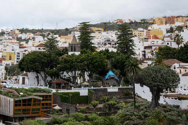
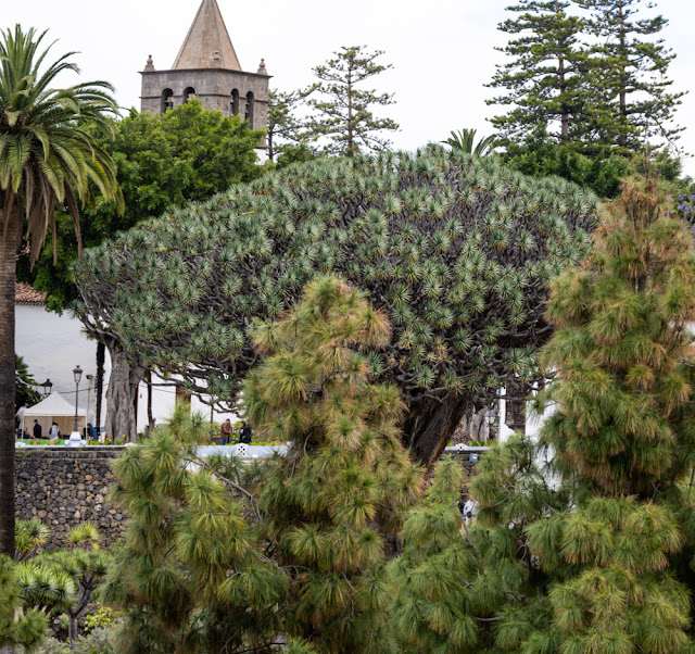
The photo above (on the right) and below shows the El Drago, also known as Drago Milenario and Drago de Icod de los Vinos, is the oldest and largest living specimen of Dracaena draco, or dragon tree. It is estimated to be between 800-1000 years old, although the age is disputed. It is one of the symbols of Tenerife and was declared a national monument in 1917. It's image appears on the 1,000 pesetas note.


Below are a few more photos taken from my veranda before we sailed and as we sailed.


I will finish this post with my Geo Tracker map and data for today's trip.

As may be seen, we traveled the largest part of the island.
Our tour took us 132 miles over 8 hours. Our elevation ranged from 21 feet to 7780 feet.

Overall, today's excursion was very good. We had an opportunity to see much of the varied terrain of the island and enjoy some of its food as well. I was very impressed with Tenerife. It was modern, clean and had excellent infrastructure, the best we have seen since Singapore.
We travel most of tomorrow, scheduled to arrive in Agadir, Moracco at 6:00 PM.


No comments:
Post a Comment